My Own Car System, Rear Camera, Offline Maps & Routing on Raspberry Pi part I
- Geo Go Qt
At first I needed a car rear camera, one thing led to another…
My Car, from 2011, only has an LCD display and no rear camera, so I bought a PAL rear camera, we passed some cables from the rear window to the front then everything begun.
Here is my journey to transform my car into a modern system running on RPi3 (a never ending project).
Hardware
I’m using an Rpi3 (old model).
With Arch for ARM but any system will do.
The screen is an Eleduino Raspberry Pi 7 Inch 1024x600 Pixel IPS Hdmi Input Capacitive Touch Screen Display
An USB 2.0 EasyCap to retrieve the composite signal.
No driver needed for both the screen and the video capture dongle.
mplayer tv:// -tv driver=v4l2:device=/dev/video0:fps=25:outfmt=yuy2:norm=PAL
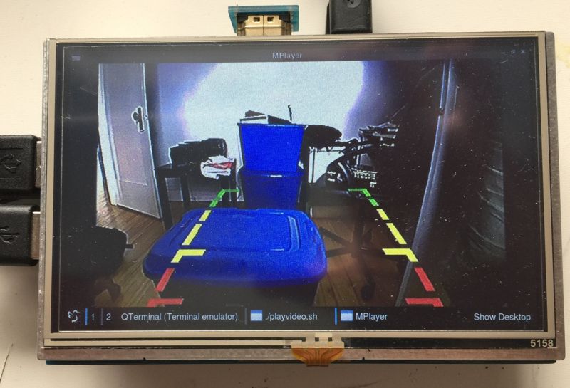
mplayer is working out of the box, so I thought everything was okay with the camera, so I thought.
I needed a GUI to display the camera and the date (at this this time this project was just a rear camera display).
So I choose Qt & Golang, not the normal contenders but I can’t handle C++ and had experiences with QtGo, and modern Qt apps are just QML code anyway… So I thought…
I’ve started to code a small QML app but when displaying the video I got:
ERROR: from element /GstPipeline:pipeline0/GstV4l2Src:v4l2src0: Device '/dev/video0' does not support progressive interlacing
Additional debug info:
gstv4l2object.c(3768): gst_v4l2_object_set_format_full (): /GstPipeline:pipeline0/GstV4l2Src:v4l2src0:
Device wants interleaved interlacing
Qt via Gstreamer does not allow non interlaced videos :(
One solution is to force a pipeline with an interlacer.
Easy on the command line
gst-launch-1.0 v4l2src ! interlace ! xvimagesink
Not that easy via Qt I had to patch the Qt Gstreamer plugin camerabinsession.cpp to insert a filter on the preview:
at the end of GstElement *CameraBinSession::buildCameraSource()
    const QByteArray envInterlace = qgetenv("QT_GSTREAMER_CAMERABIN_VIDEO_INTERLACE");
    if (envInterlace.length() > 0) {
        GstElement *interlace = gst_element_factory_make ("interlace", NULL);
        if (interlace == NULL)
            g_error ("Could not create 'interlace' element");


        g_object_set(G_OBJECT(m_camerabin), "viewfinder-filter", interlace, NULL);

        #if CAMERABIN_DEBUG
            qDebug() << "set camera filter" << interlace;
        #endif
        gst_object_unref (interlace);
    }
GPS
I had a serial GPS around, why not display a moving map?
Enable serial port in /boot/config.txt (note Bluetooth must be disabled …)
enable_uart=1
dtoverlay=pi3-disable-bt
pin 8 TXD
pin 10 RXD
remove console=ttyAMA0,115200 and kgdboc=ttyAMA0,115200 from /boot/cmdline.txt
I thought it would be very easy to read NMEA via serial.
It was, gpsd worked in seconds but … it seems we can’t disable the auto speed, equal 4s lost at start.
Plus Qt is using libgeoclue or Gypsy which does not want to talk with gpsd.
I tried both of them, they didn’t work, it’s a mess to debug, documentation is just the API…
So one thing led to another… I’ve written a very small and simple gpsd in Go with a gRPC interface, so it can be queried from anything.
It’s also a bit more advanced since it can map match & route match the positions with OSRM.
Offline maps
OpenMapTiles project is great to generate vectors data in MBTILES format, you can serve them with mbmatch.
Qt Map QML can display them using the mapboxgl driver, some free styles are provided.
Here is an example QML Map plugin.
    Plugin {
        id: mapPlugin
        name: "mapboxgl"
        PluginParameter{
            name: "mapboxgl.mapping.additional_style_urls"
            value: "http://localhost:4000/osm-liberty-gl.style"
        }
    }
Note on X11 and EGL:
Using the mapboxgl renderer under X11 on the Rpi3 is taking a lot of ressources.
Qt5 is capable of directly talking to the GPU without X11, the performance difference is night and day.
So just run your Qt app without X11 with the following env vars.
QT_QPA_PLATFORM=eglfs:/dev/fb0
QT_QPA_EGLFS_HIDECURSOR=yes
Offline Routing
Hopefully the provided Qt osm plugins knows how to route using the OSRM API.
So you can run a local OSRM backend for routing and it will just work.
Generate the route indexes.
osrm-extract -p /usr/share/osrm/profiles/car.lua quebec-latest.osm.pbf
osrm-contract quebec-latest.osrm
osrm-routed quebec-latest.osrm
    Plugin {
        id: routePlugin
        name: "osm"
        PluginParameter{
            name: "osm.routing.host"
            value: "http://localhost:5000/route/v1/driving/"
        }
    }
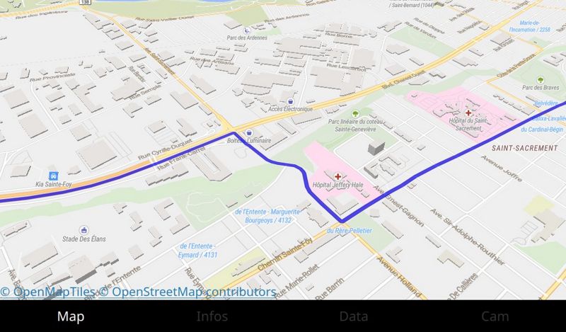
The app can display the rear camera and a moving map !!
Part 2 will be about searching places by extracting OSM data and indexing them in a small Go program that can run on the rpi, reading ODB data from the car via Bluetooth, packaging the whole thing and open sourcing some code.